VITAL II measurement campaign
Published: 1, July, 2026
How to fill the gaps in weather observations?
VITAL II measurement campaign to evaluate new methods for atmospheric boundary layer profiling ongoing in Western Germany around JOYCE
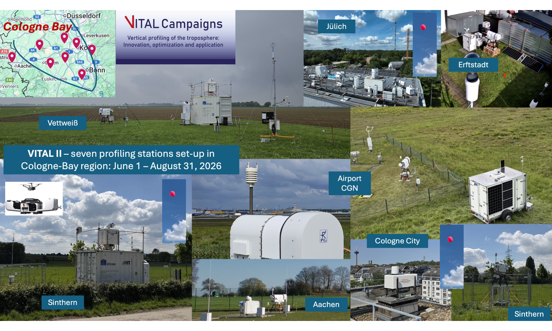
The measurement campaign VITAL II is currently taking place in the Cologne Bay area in Western Germany including the ACTRIS Cloud Remote Sensing NF JOYCE, focusing on profiling the atmospheric boundary layer.
The reliability of local, short-term (up to 24 hours) weather forecasts has steadily improved over recent decades. However, particularly during summertime convective situations the forecast is often inaccurate. This is not only due to the deficiencies of the forecast models, e.g. regarding spatial resolution and parameterization, but also to a lack of initial observations. Continuous and spatially comprehensive observations are particularly lacking in the atmospheric boundary layer, i.e. in the lowest 1–2 kilometers above ground. Observations of temperature, humidity and wind profiles with high spatial and temporal resolution would be particularly valuable to capture the crucial processes in the boundary layer.
To demonstrate that this measurement gap can be partially closed within a model region, the VITAL II measurement campaign was designed, installed and successfully launched on June 1st. VITAL II is a research collaboration within the Hans-Ertel-Centre for Weather Research (HErZ), between the German Weather Service (DWD), the universities of Cologne, Bonn, Tübingen, Hamburg, Munich and Frankfurt, and the Karlsruhe Institute for Technology (KIT)
From 1 June to 31 August 2026, HErZ researchers operate a dense network of seven ground-based remote sensing stations (Fig. 1) and over 50 additional weather stations in the Cologne Bay area within a ~50 km radius around JOYCE. All remote sensing sites are equipped with a microwave radiometer (MWR), a Doppler lidar and many sites have additional water vapor lidars (DIAL or Raman) and precipitation gauges. The remote sensing instruments are being operated and processed according to ACTRIS standards, particularly regarding MWR.
The ground-based observations are combined with data from the new IRS (Infrared Sounder) on the geostationary satellite MTG-S1 (Meteosat Third Generation Sounder). VITAL II observations are supplemented by meteorological drone measurements during an intensive measurement phase (3–14 August). Throughout the whole VITAL II campaign, students from the Universities of Cologne and Bonn will additionally launch up to 120 weather balloons (radiosondes) – as reference measurements.
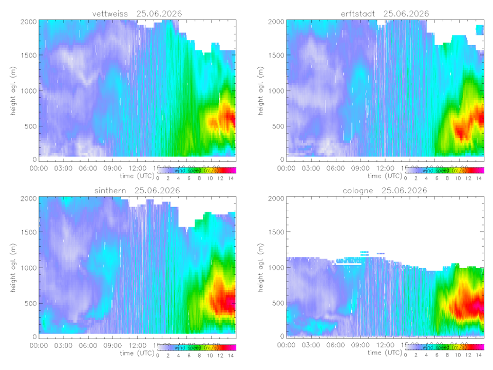
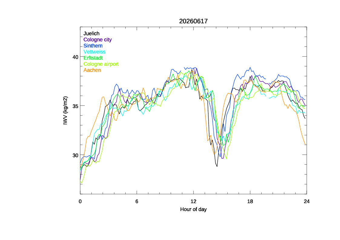
The VITAL II data obtained will capture the lowest 1–2 kilometers of the atmosphere above the target area with a temporal and spatial resolution never before achieved. The synergy between ground-based and satellite-borne measurements will demonstrate how accurately the atmospheric boundary layer can be characterized by simultaneous measurements ‘from below and from above’. The derived atmospheric conditions will be used to quantify the impact of the additional observations on weather prediction (data assimilation), to improve the ICON DWD forecast model (turbulence parameterizations) and to learn more about the development of thunderstorms and associated temperature drops (‘cold pools’).
First results show that this unique dataset that is being gathered during VITAL II will be very valuable for further scientific work (see Fig. 2 and 3).
More information here
Real-time data quick looks can be found here