ACTRIS mobile platform LACROS started to explore aerosols and clouds at the edge of the Southern Ocean
Published: 15, December, 2025
The Leipzig Aerosol and Cloud Remote Observations System LACROS of Leibniz Institute for Tropospheric Research (TROPOS) successfully started into the 1.5-year spanning goSouth-2 measurement campaign in Invercargill, Aotearoa, New Zealand, at the gateway to the Southern Ocean. The goal is to investigate aerosols and clouds and their interactions in contrasting airmass regimes arriving from either the clean Southern Ocean or aerosol-burden Australia. Especially the new fluorescence channel of the LACROS PollyXT lidar system complements the mobile exploratory platform with observational capabilities which were never before available in the midlatitudes of the Southern Hemisphere.
18 months of observations at the southern tip of New Zealand
Since the end of August 2025, the Leipzig Aerosol and Cloud Remote Observations System LACROS of Leibniz Institute for Tropospheric Research (TROPOS) has been deployed at the southern tip of New Zealand for the goSouth-2 field campaign. The goSouth-2 project (https://gosouth2.tropos.de) under the lead of TROPOS is aiming to contribute a unique long-term dataset of remote-sensing and in-situ measurements of cloud-relevant aerosol properties and associated cloud properties for the northern edge of the Southern Ocean. The measurements are scheduled to last for 18 months until March 2027.
Unique opportunities to investigate cloud processes in extremely clean environments
The region of the Southern Ocean in the midlatitudes of the southern hemisphere is a current hot-spot of research related to aerosol-cloud interactions. Despite ongoing efforts, this region is still prone to strong biases between measurements and simulations of the surface radiation budget. These differences are widely suspected to be caused by an incomplete representation of the lack of aerosol particles in this region, which is so far not considered in state-of-the-art model simulations. Especially aerosol-cloud-interaction processes appear to be misrepresented in the numerical simulations, given that weather models are tuned to parameterizations and observations from the much more aerosol-burdened northern hemisphere. The location of goSouth-2 in Invercargill holds, in addition, a special value because it is equally prone to either Southern-Ocean airmasses arriving from the south, as well as from the rather aerosol-burdened Australian landmass. Besides the investigation of Southern-Ocean cloud and aerosol processes, thus contrasting studies in more polluted conditions are also possible.
Measurements cover aerosol and cloud profiling as well as surface in-situ observations
LACROS has been deployed on the premises of the New Zealand MetService in Invercargill (46.4173 °S, 168.3307 °E, 3 m a.s.l., https://cloudnet.fmi.fi/site/invercargill). A total of 15 active and passive remote sensing and in-situ instruments are operated, so that the site represents a full cloud remote sensing (CRS) and aerosol remote sensing (ARS) station. See the instrument listing in the photograph! Highlights are the first-ever built PollyXT lidar with a 460-nm fluorescence channel and a multi-frequency (partly scanning) cloud radar setup. Essential surface in-situ observations of cloud-relevant aerosol properties, such as aerosol number size distribution, cloud condensation nuclei concentration, and low-volume sampling for ice nucleating particle off-line analysis, complement the remote-sensing observations.
goSouth-2 will yield new insights about the properties of aerosols and clouds over the Southern Ocean, their interactions, and the role of atmospheric air motions in cloud processes. First conclusions are that aerosol in the free troposphere is rare. If present, it can be assigned to wildfires in Africa and Australia. Ice formation in clouds warmer than -4°C is frequently absent, confirming the lack of efficient INPs. The structure of the planetary boundary layer of the marine environment is very complex, containing multiple embedded sub-layers of differing aerosol properties, whose effect on cloud formation is subject to subsequent analysis steps.
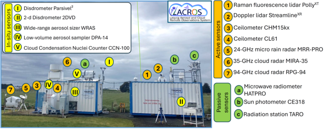
Fig. 2: Site setup of LACROS in Invercargill.
Collaborations will foster the scientific benefits of goSouth-2
It’s not only that LACROS combines aerosol and cloud remote sensing with surface in-situ measurements. Besides this on-site collaboration of 3 key ACTRIS facilities, goSouth-2 is strongly involved in collaborations with parallel activities. Those include the 6-week datasets of in-situ aircraft observations performed around New Zealand during the HALO-South campaign. Overpasses of the EarthCARE satellite are continuously being monitored for Cal/Val and science studies. In collaboration with the University of Leipzig, TROPOS runs the 2-PhD comprising research project ACADIA, while it has another Phd student dedicated to the data analysis via the EU project CleanCloud. Together with the University of Canterbury, the University of Leipzig runs another remote-sensing field site at the Tāwhaki Aerospace Center (43.83°S,172.54°E, 3 m a.s.l.) at the eastern coast of the South Island of New Zealand, which allows for the study of the transformation of air masses during the passage above the New Zealand landmass. University of Canterbury and the New Zealand company The Air Quality Collective run a New-Zealand funded research project which will use the observational datasets for improving high-resolved climate model simulations of the region. A team from the University of Auckland cooperates with TROPOS to take over the INP analysis of the filter samples, and MetService provides fundamental support in Invercargill by means of the provision of radiosonde data and weather radar observations.
Thus, the future for a successful exploitation of the goSouth-2 datasets looks bright. Glad to see that ACTRIS Cloudnet data has been available since the start of the campaign: https://cloudnet.fmi.fi/site/invercargill
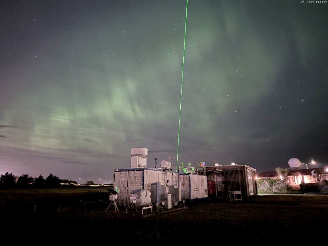
Header Image: The LACROS mobile exploratory platform as it is deployed in on the premises of MetService New Zealand in Invercargill. Credits: Mike Bailey.