ACTRIS contribution the Joint Aeolus Tropical Atlantic Campaign
Published: 9, April, 2022

From July to September 2021, the European Space Agency (ESA) organised the Joint Aeolus Tropical Atlantic Campaign (JATAC), with the main aim of providing quality-assured reference measurements for the validation of the Aeolus satellite mission and to collect information for ESA’s upcoming EarthCARE mission and future satellite concepts such as the Earth Explorer 11 Wivern candidate mission. JATAC also supported a range of scientific objectives such as investigations of the Saharan Air Layer, African Easterly waves and jets and convection in the Intertropical Convergence Zone.
The ground-based component of the JATAC campaign, ASKOS, is a component supported by ACTRIS facilities and groups. The experiment has been designed, deployed and implemented by the National Observatory of Athens (NOA) in close collaboration with the Leibniz Institute for Tropospheric Research (TROPOS), the National Institute for Research and Development for Optoelectronics (INOE), and the National Research Council of Italy - IMAA (CNR-IMAA). Its name is closely connected to Aeolus, the Greek god of the winds: ASKOS is the Greek word for the god’s legendary bag that contained all the storm-winds.
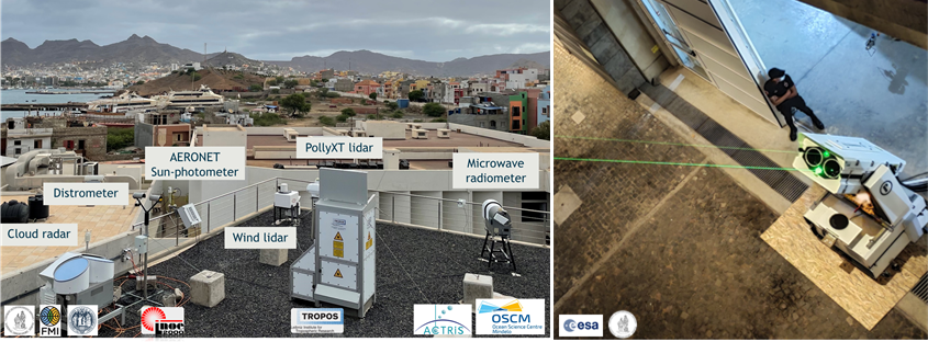
The campaign was held in the tropical islands of Cape Verde where a dedicated orbit shift of Aeolus brought the satellite even closer to the ACTRIS exploratory platforms. The ASKOS component was based in Mindelo on the Island of São Vicente in Cape Verde, where high quality ground-based wind, aerosol and cloud observations were collected using advanced ACTRIS instrumentation aiming to provide reference values for Aeolus Calibration and Validation (Cal/Val) efforts. More specifically, at the Ocean Science Center in Mindelo (OSCM), an ACTRIS aerosol and cloud remote sensing facility was set up since June 2021. The instrumentation includes the multiwavelength-Raman-polarization lidar PollyXT, an AERONET sun photometer, a Scanning Doppler wind lidar and a microwave radiometer (operating by TROPOS) and a cloud radar operating in the framework of the ESA fiducial reference network (FRM4Radar). In addition, next to these aerosol, cloud, and wind remote sensing facilities, the novel ground reference lidar system, eVe is operated by NOA. eVe lidar is a combined linear/circular polarization lidar system with Raman capabilities, which can mimic the observations of the space-borne lidar ALADIN onboard Aeolus. The system has been developed by NOA and Raymetrics for ESA and has been supported by ACTRIS and CARS, to include certain QA/QC tests for optimum operation.
On top of these ground-based equipment, a light-weight airplane operated by the University of Nova Gorica (UNG) was located at the airport of São Vicente during the intensive campaign in September 2021 performing in-situ measurements of the aerosol layers around the island up to an altitude of about 3 km. Additional airborne measurements up to an altitude of 8-10 km were performed by the airborne fleet situated on the island of Sal in Cape Verde and operated by the German Aerospace Center (DLR) and the Laboratoire atmosphères, milieux, observations spatiales (LATMOS).
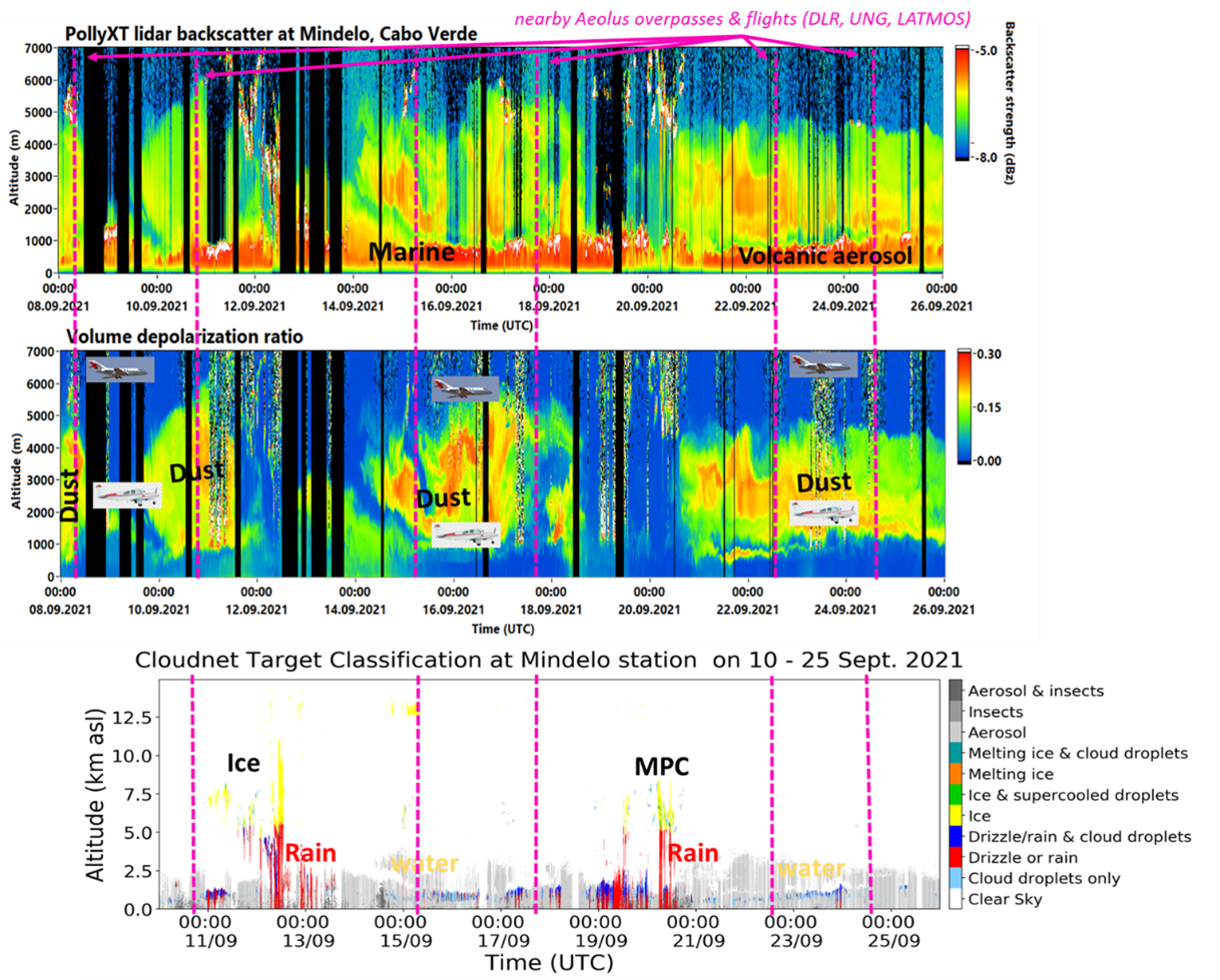
During the September 2021 operations, different aerosol types as well as different cloud phases was observed over the area. Marine aerosols was observed inside the boundary layer that extends up to 1 km altitude, topped by a Saharan dust layer that reached 6 km altitude. Volcanic aerosols originated from the Cumbre Vieja volcanic eruptions in Las Palmas, Canary Islands were also observed on 24 - 26/9. Low-level cloud, formed on top of the boundary layer, were frequently present above Mindelo site. Few events with mid-level mixed-phase clouds formed above 5 km, resulted to rain. Finally, cirrus clouds were also observed at 13 km altitude. Aeolus aerosol products have been intensively validated for the direct overpasses with the Aeolus-reference system EVE and the PollyXT lidar. The inter comparison between the ground-based lidars yielded an excellent agreement, giving confidence that they can act as ground-truth for Aeolus. As a next step, closure studies between the airborne in-situ and the ground-based measurements will be performed which will lead to an intensive insight in the microphysical aerosol properties. These studies will help to understand the representativeness of the ground-based supersite in the context of the regional aerosol distribution and thus give valuable information for validation activities for current and future spaceborne lidar and radar missions, in a region of the world where measurements are sparse. In this context, another intensive ASKOS campaign is planned for Summer 2022 on the Sao Vicente Island, comprising a bigger instrument suite and covering the prime Saharan dust outbreak season.